Published: Sunday 3rd September, 2017
By: T. Chapman
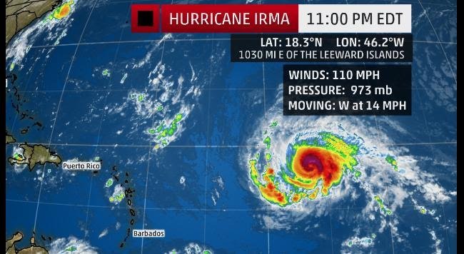
SKN PULSE – Hurricane Irma is expected to be an intense hurricane as it draws closer to the Leeward Islands in the upcoming week. It is expected that Irma will restrengthen into a categoey 3/4 hurricane in the coming days.
According to weather.com, the center of Irma is located just over 1,000 miles east of the Leeward Islands and is moving just south of due west at about 15 mph.
The intensification of Irma has slowed down after intensifying from a tropical storm Wednesday to category 3 hurricane Thursday in just 30 hours.
With Irma continuing to attempt cycles of reorganization which are referred to as eyewall replacement cycles; a new eyewall is expected to form and replace the old one. A few of these changes are likely to occur with Irma.
The Fluctuations in intensity will continue over the next few days especially Later this weekend into next week. Reports state that Irma is expected to move over progressively warmer waters and into a more moist environment, but wind shear is expected to increase.
This leads to a bit of uncertainty in additional strengthening, but Irma is still expected to reach category 3/4 status by early week. Regardless of any strengthening trend, Irma is expected to expand its field of tropical storm and hurricane force winds as it moves westward.
To figure out the hurricane”s intensity and size, Hurricane Hunters will begin flying reconnaissance flights in Irma beginning later today, (Sunday 3rd September).
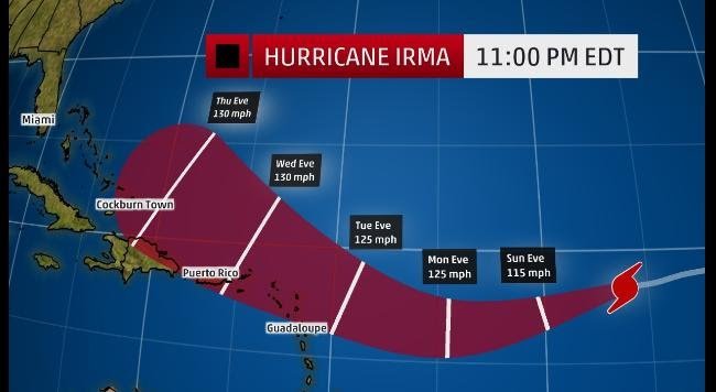
For the next five days, Irma will move west-southwestward, then west-northwest again on the south side of a ridge of high pressure called the Bermuda high, centered in the central Atlantic.
Attention: Leeward Islands
Irma is expected to reach the longitude of the Lesser Antilles (eastern Caribbean) late Tuesday or early Wednesday and Irma could be a formidably intense hurricane at that time.
The current trend being highlighted in the different computer models that predicts the future track of hurricanes is showing a subtle southward trend, toward the Leeward Islands.
A Weather.com article posted earlier states that “It is looking like direct impacts to the Lesser Antilles are more likely to be in the northern Leewards from Guadaloupe northward, but this may change in the coming days”.
For now, residents of the Leeward Islands, Puerto Rico, the Virgin Islands and the Bahamas should follow the progress of Irma.
While a direct Irma impact is not a foregone conclusion, the chances of impact in the Lesser Antilles are increasing.
(www.weather.com)


