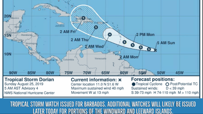
A Tropical Storm Watch is in effect for Barbados.
As per meteorologist reports, tropical storm conditions are possible there by late Monday. Additional watches will likely be issued later today for portions of the Windward and Leeward Islands. Elsewhere, interests in Puerto Rico and Hispaniola should monitor the progress of Dorian.
The storm is centered as of 5 a.m. AST about 555 miles (890 km) east-southeast of Barbados. It’s moving toward the west near 13 mph (20 km/h). This motion is expected to continue today.
On the forecast track, Dorian is expected to be near the central Lesser Antilles late Monday or early Tuesday.
Maximum sustained winds remain near 40 mph (65 km/h) with higher gusts.
Tropical-storm-force winds extend outward up to 25 miles (35 km) from the center. Some strengthening during the next 48 hours is forecast, and Dorian could be near hurricane strength over the eastern Caribbean Sea.
Swells generated by Dorian will be affecting portions of the Lesser Antilles by late Monday. These swells could cause life- threatening surf and rip current conditions. Please consult products from your local weather office.
The next complete advisory will be issued by NHC at 11 a.m.


