Sourced Information:
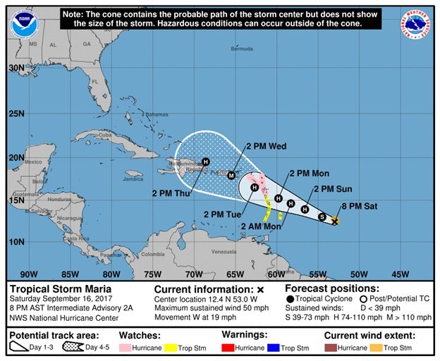
At 800 PM AST (0000 UTC), the center of Tropical Storm Maria was located near latitude 12.4 North, longitude 53.0 West. Maria is moving toward the west near 19 mph (30 km/h). A slowerwest-northwestward motion is expected during the next couple ofdays. On the forecast track, Maria is expected to approach the Leeward Islands on Monday.
Maximum sustained winds are near 50 mph (85 km/h) with higher gusts. Strengthening is expected during the next 48 hours, and Maria is forecast to be a hurricane when it approaches the Leeward Islands early next week. Tropical-storm-force winds extend outward up to 45 miles (75 km) from the center. The estimated minimum central pressure is 1002 mb (29.59 inches).
WIND: Hurricane conditions are possible within the hurricane watch area by Monday night or Tuesday, with tropical storm conditions possible on Monday. Tropical storm conditions are possible in the tropical storm watch area on Monday.
STORM SURGE: A dangerous storm surge accompanied by large and destructive waves will raise water levels by as much as 3 to 5 feet above normal tide levels within the hurricane watch area.
RAINFALL: Maria is expected to produce total rain accumulations of 6 to 12 inches with isolated maximum amounts of 20 inches across portions of the central and southern Leeward Islands through Tuesday night. Rainfall amounts of 2 to 4 inches with isolated maximum amounts of 8 inches will be possible for portions of the northern Leeward Islands through Tuesday night. These rains could cause life-threatening flash floods and mudslides.
SURF: Swells generated by Maria are expected to begin affecting the Lesser Antilles by Sunday night. These swells are likely to cause life-threatening surf and rip current conditions. Please consult products from your local weather office.
NEXT ADVISORY
-------------
Next complete advisory at 1100 PM AST.

Forecaster Beven


